Google Mars launched today to
much fanfare. It provides a map of the entire surface of the red planet,
using more than 17,000 photos taken by the thermal emission camera on the
Mars Odyssey orbiter, which takes pictures in infra red and visible light,
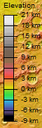
as well as the topographic maps made by MOLA, the Laser Altimeter on Mars
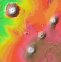
Global Surveyor. Some key sites are imaged in much greater detail, such as
the giant volcano Olympus Mons, the landing sites for the two Mars rovers,
Spirit and Opportunity, and the grand canyon of Mars, Valles Marineris.
“It really gives you the big picture view of Mars,” says Robert Burnham, part of the team at Arizona State University, Tempe, that created the martian map. It’s more likely to be used by space fans rather than for research purposes, but it does provide a platform for higher resolution images to be added by craft such as Mars Reconnaissance Orbiter, which arrived at the planet on 10 March. Have a look at the cool fly-through videos at the THEMIS website – you can even download special versions onto your iPod.